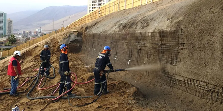
A contractor excavating for a new housing scheme on the north side of Drogheda hit a lens of saturated glacial till three meters down. The cut face started slumping within hours. That kind of surprise stops work dead and burns contingency fast. Slope stability analysis in Drogheda is not a box-ticking exercise: the town sits on a complex mix of glacial deposits, weathered shale, and river terrace gravels that behave very differently when wet. We run the analysis to quantify the factor of safety before a spade goes in the ground. That means fewer emergency shutdowns, no redesign loops mid-construction, and a clear remediation path if the numbers are tight. For deep cuts near the Boyne or retaining structures on sloping sites, we often combine the stability model with site investigation via SPT drilling to pin down the shear strength parameters that drive the calculation.
A slope that looks stable in August can fail in February. Drogheda's highest groundwater levels coincide with winter storms: the analysis must use the wet-season phreatic surface, not the dry one.
Methodology and scope
Drogheda's development has always been shaped by its topography. The medieval core clings to a steep ridge between the Boyne Valley and the coastal plain, and the modern suburbs have pushed onto slopes that were farmland for centuries. Each phase of expansion left its mark on the subsoil: old mill races backfilled with rubble, nineteenth-century quay walls buried under later reclamation, and cut-and-fill platforms for twentieth-century housing. A desk study alone misses these layers.
Our slope stability analysis in Drogheda starts with a geomorphological walkover to spot old landslide scars, seepage points, and vegetation stress. Then we model the critical section using limit equilibrium or finite element methods, depending on the geometry. Material strength comes from lab testing, not textbook tables. For slopes where pore pressure is the controlling variable, we integrate
in-situ permeability testing to calibrate the groundwater regime before running the stability model. The output is a Factor of Safety that the design team can defend to insurers, funders, and the local authority.
Applicable standards
EN 1997-1:2004 (Eurocode 7: Geotechnical design), EN 1998-5:2004 (Eurocode 8: Design of structures for earthquake resistance – Foundations, retaining structures), IS EN 1997-2:2007 (Ground investigation and testing), CIRIA C580: Guidance on embedded retaining wall design, FHWA-NHI-05-094: Soil Slope and Embankment Design
Frequently asked questions
How much does a slope stability analysis cost for a typical residential site in Drogheda?
For a single residential plot with a cut or fill slope up to about 4 meters high, the analysis typically falls in the range of €1,060 to €3,870. The final figure depends on whether we need to commission additional boreholes, the complexity of the groundwater regime, and the number of cross-sections that must be analyzed. A site with a history of instability will sit at the upper end because the back-analysis and remediation modeling take more engineering time. We can provide a fixed-price proposal after a one-hour site visit.
Do I need a slope stability analysis if my site in Drogheda looks flat?
A site can look flat and still have stability issues if there is a proposed basement excavation or if the neighboring property is significantly lower. Any cut deeper than 1.5 meters in Drogheda's glacial till warrants at least a qualitative assessment. If the adjoining ground slopes more than about 10 degrees, a quantitative analysis is usually required by the building control authority. We can advise after a brief walkover.
What is the difference between limit equilibrium and finite element analysis?
Limit equilibrium methods divide the slope into slices and calculate the balance of driving and resisting forces. They are fast, well-understood, and accepted by every regulatory body. Finite element analysis models the soil as a continuum and can capture complex failure mechanisms, progressive failure, and soil-structure interaction. We use finite element when the slope geometry is irregular, when reinforcement elements like nails or piles are included, or when deformation predictions are needed alongside the factor of safety.
How long does a slope stability study take from instruction to report?
A straightforward analysis for a single cross-section, with existing ground investigation data, can be turned around in seven to ten working days. If we need to commission drilling, in-situ testing, and laboratory triaxial or shear box tests, the full program extends to four to six weeks. We always sequence the work so that preliminary findings reach the design team early, allowing the project program to move forward while the detailed report is finalized.