Drogheda’s layered history, from its Norman foundations to its Victorian industrial expansion along the Boyne, has left a subsurface as stratified as its streets. The Millmount mound itself is a testament to how local geology shapes development. For modern engineering projects, understanding this hidden stratigraphy requires more than boreholes alone. Seismic tomography provides a continuous subsurface velocity model, mapping the transition from glacial tills to the underlying Carboniferous limestone bedrock that defines the region’s bearing capacity. This method, combining refraction and reflection wave analysis, resolves anomalies that borehole spacing might miss, offering a full profile without the gaps. In a town where redevelopment often encounters buried river channels and variable rockhead depths, integrating geophysics with SPT drilling ensures the ground model reflects actual conditions rather than interpolation alone.
Velocity gradients don’t just map rockhead; they quantify rippability, directly informing whether mechanical excavation can replace blasting in Drogheda’s limestone.
Local considerations
A 24-channel ABEM Terraloc or similar seismograph, coupled to a ruggedized field laptop, forms the core acquisition system. In Drogheda, ambient vibration from the M1 motorway corridor and the Dublin–Belfast railway line introduces low-frequency noise that masks deep reflections. The engineering risk lies not in equipment failure but in misinterpreting velocity inversions: a high-velocity gravel lens overlying a lower-velocity clay can fool a simple refraction interpretation, hiding a potential settlement zone. Post-processing with tomographic inversion algorithms, rather than traditional delay-time methods, mitigates this by iteratively fitting a curved-ray model to the travel-time data. Without this step, a site investigation might approve a foundation design that underestimates differential settlement, especially where the Boyne’s paleochannels have deposited soft organic silts invisible to surface reconnaissance.
Frequently asked questions
What is the typical cost for a seismic refraction tomography survey in Drogheda?
The investment for a seismic tomography survey in Drogheda generally ranges from €2,230 to €4,990, depending on the total lineal metres, the number of spreads, and whether reflection processing is required alongside refraction. Urban surveys with limited access and high noise levels tend toward the upper end due to the additional data processing involved.
How does seismic tomography compare to MASW for assessing ground stiffness?
MASW focuses on surface-wave dispersion to produce a 1D or 2D shear-wave velocity (Vs) profile. Seismic tomography using refraction focuses on P-waves to map layer geometry and rippability. They are complementary: tomography delineates the geological structure, while MASW provides the Vs30 for site classification under EN 1998-1.
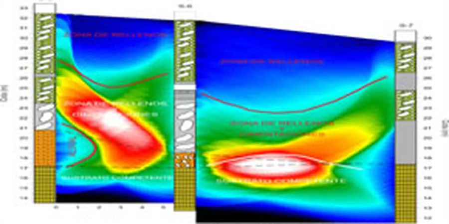
Can seismic tomography identify karst features in Drogheda’s limestone?
Yes, seismic tomography can identify velocity anomalies consistent with karstic weathering. Voided or clay-filled cavities produce a marked drop in P-wave velocity relative to competent limestone. Reflection data further helps by imaging disruptions in sub-horizontal reflectors, though confirmation with targeted drilling is always recommended for critical structures.
What site constraints in Drogheda affect the seismic survey layout?
Drogheda’s historic core presents challenges: narrow access, heavy traffic along the quays, and vibration noise from the railway and M1. These factors often require shorter geophone arrays, nighttime acquisition to reduce cultural noise, and solid filtering during seismic data processing to extract reliable first arrivals.